Basic HTML Version


41
SAMC
o
T
• ANNUAL REPORT 2013
A mathematical model describing the effect is based on
Foppl - von Karman equations (1907) describing large
deflections of thin plates.
The narrowing of Svea Bay is a potential place for
constructing a fjord cross-section for car transporta-
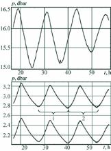
tion (Figure 29). Measurements of sea currents in this
place confirmed water influx from river in winter time
and high variability of sea current velocities induced
by semidiurnal tide (Figure 30). The highest velocities
measured in the strait between Vallunden lake and
the fjord reached 2 m/s. The results of field studies
were reproduced with numerical simulations based on
shallow water equations. The strong current driven by
local gradients of the water pressure is responsible for
sediment transport which can increase significantly
in ice season because of higher shear stresses at the
bottom in the ice.
Coal boats use the channel Akselsundet between
Akseløya Island and land on the way to and from the
coal quay Kapp Amsterdam near Svea (Figure 27). The
width of the channel is less than 1 km, its water depth
below 25 m, and the maximal speed of sea current can
exceed 3 m/s. These challenging conditions mean that
coal boats with deadweight up to 70000 T can pass the
channel only in times with low currents. The construc-
tion of a transfer function between the current speed in
the channel and water level gradient over the Akseløya
is a main goal of the field work.
a) b)
Figure 28. Sea currents measured with ADCP Aquadop in the straight between Svea Bay and Vallunden lake (a) and with
ADCP RDI 1200 kHz in Svea Bay (b).
a) b)
Figure 27. Locations of sea current profiling and tide measurements in Svea Bay (a). Example of semidiurnal elevation of
the water level by tide measured in Svea Bay and Vallunden lake (b).

